A good deal of historical information on Oswego County, New York is available at the Oswego County Historical Society's web page. (Note: I prefer not to provide active links to pages outside my own site as they tend to change frequently, resulting in broken links and a maintenance nightmare.) Of particular interest is the Landmarks of Oswego County New York, edited by John C. Churchill, L.L.D., assisted by H. Perry Smith & W. Stanley Child, Syracuse, N.Y., D. Mason & Company Publishers, 1895. The OCHS web page provides the book in its entirety in web format.
Very similar information is contained in "History of Oswego County, New York" by Crisfield Johnson, Published by L.H. Everts & co., Philadelphia, 1887. This book is available in its entirety in several formats at the Internet Archive web page (archive.org).
Oswego County was part of the Revolutionary War Land Grant program. Excellent information on the land grants is provided at the Seneca County, New York U.S. Gen Web site hosted by Ancestry dot com. The land grants were given as compensation for service during the Revolutionary War. The amount of land awarded depended on the soldier's rank, with privates receiving a lot of 500 to 600 acres. The lot numbers in the Landmarks of Oswego County book refer to the Military Land Grant lot numbers. The tract in Oswego County was called Hannibal in the Military Land Grant document.
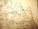
Several family members were very early settlers of Oswego, as documented in the Landmarks of Oswego County book. Specifically, David Gray and Clarissa Patchin settled on Lot 21 in 1812. Nathaniel Beckwith and Elizabeth Rich lived on a farm in Fitch's Corner, located in Lot 20, during the time of the War of 1812. Slightly later, Jesse Gray and Thyrza Beckwith purchased land in Lot 14, just North of their parents properties. The relative locations of the lots are shown in the Military Land Grant map below. This map is from the first sheet of the DeWitt's State Map of New York, dated 1793. The map is available, in its entirety, at the New York State Library's web site.
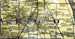
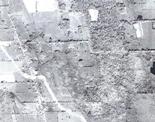
I originally thought the families purchased an entire lot, consisting of about 600 acres each. However, I now know that the lots were subdivided and the families purchased only a portion of the referenced lot. The following historical maps provide additional information on the location of Gray-Beckwith-Stevenson family members and many of their neighbors.
Information on land purchases in Oswego can be searched at a site hosted at http://www.ellsworthfamily.net/oswego-deed-index/search.php which is titled "Search the Oswego Deed Indexes."
I have found additional historical information on Oswego at my favorite site, the "Old Fulton Post Card" web page located at http://www.fultonhistory.com/Fulton.html. The articles are provided below:
|
|